Aaland Islands GPS Charts 4.4.3.7.3
Paid Version
Publisher Description
Aaland Islands GPS Charts - Marine and Fishing Charts - The power of a GPS plotter in the palm of your hand
Flytomap is a valid and interesting alternative
Featured on the Deck
Featured on Geomedia
Worldwide Marine and Outdoor Maps available when connected, thanks to viewer.flytomap.com
Worldwide Satellite images overlay on charts
Worldwide Terrain features overlay on charts, thanks to Open Street Map, Open Cycle Map, Earth,topo maps by ESRI
Now with NOAA raster charts seamless with continuous updates from the official Government server
Now with ActiveCaptain - Worldwide boaters community * 200.000 + Captains
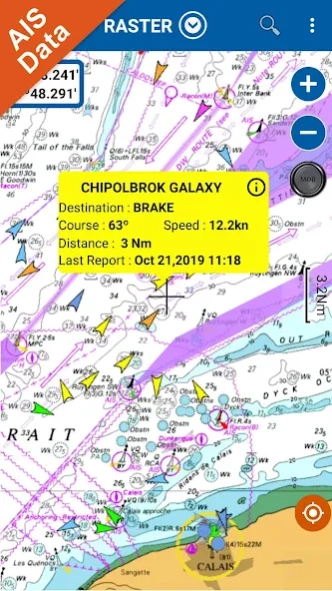
Live AIS now available
Real time map view of your boat & boats near you, worldwide.
No AIS receiver required, just your mobile!
Various icons depict different vessel categories.
Select any target to see vessel details such as name, MMSI, IMO, call sign, status, speed, heading, coordinates, distance from your GPS location & more.
Use to Explore:
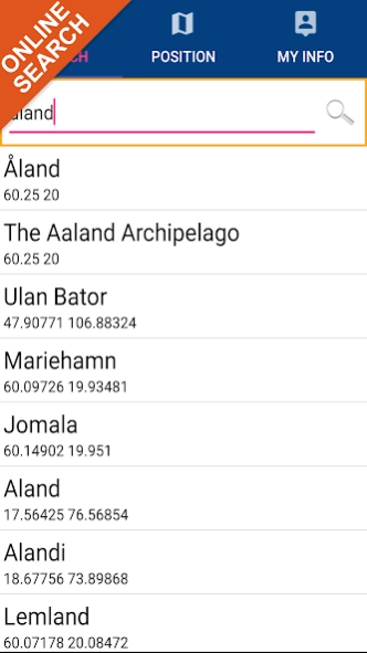
√ Latitudes and Longitudes to go to your favorite places
√ Search your Favorite points directly
√ Zoom, Rotate and Pan fast just by a finger touch
√ With Head Up & Course Up feature
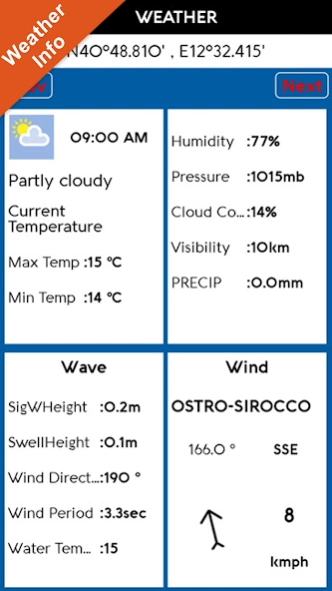
√ Local Marine Weather forecast at a tap
√ Geocompass
√ Navigate and see your GPS position on the map
√ Heading Vector Towards the direction movement
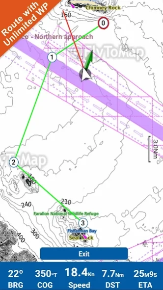
√ Distance Measurement Tool to easily calculate the distance from one location to another
√ Insert the target/destination & see in real time your speed, distance & bearing
√ background mode - Flytomap works in background as well, you can swap with another app and receive/make calls send sms while panning and zooming.
√ Unlimited Tracks share via email, visible on Google, Flytomap Viewer, KMZ format - Store your track without the need of cellular data or mobile signal
√ KMZ KML from / to GPX Converter
√ Optimized battery usage
√ ActiveCaptain
• View and contribute to the best boaters community available in the world
• Continuous update of all info (including reviews from the deck) about
• Marinas
• Anchorages
• Hazards
• Local Knowledge
√ And so much more to come - It’s the only app you will ever need! Our charts are installed on: NAVICO LOWRANCE B&G NORTHSTAR EAGLE SIMRAD
Follow us:
▶Twitter @flytomap
▶Web Site flytomap.com
▶Web App viewer.flytomap.com
▶Facebook facebook.com/flytomap
The entire cartography of Aaland Islands is included in this application.
Flytomap is committed to constant improvement, this App is developed with the help of professional boaters to get the best experience on the sea, we listen to our users and systematically add the most requested features.
Thank you for the feedback!
Additional info about Flytomap products
WATER MAPS (Marine)
Water map navigator is the new ‘Marine Navigator for all mobile devices contains embedded Electronic Nautical Charts (ENC) from NOAA compressed to a large coverage.You can now download the application and transform your Phone in a chart plotter with best NOAA, ENC S57 cartography; which includes Anchoring areas, Fishing areas,restriction areas, obstructions, rocks, Buoys, Beacons, Lights, Depth contours with Values display on map, Spot Soundings and more. The only marine app’s available in the market with such huge information. Every effort is made to be as accurate as possible when presenting information for every destination.
LAKE MAPS
We offer high quality lake maps with detailed information & important features compressed to assure the larger coverage in USA region. Lake maps contain most important DNR lakes with detailed ‘Depth Contours, Boat Ramps, Fishing spots etc. Also includes Trails, Roads and Railways information.
TRAVEL MAPS
These Maps treat you mostly with information of both Marine & terrain correspondingly. These are the most preferable Maps to travel especially for fascinating recreational voyages, map focus the best Beach spots along the Coast line, Major ports, Sailing, Fishing, Picnic areas, & much more. Introducing guide in map navigator for easy references
“We work to delight your moments”
! Enjoy great Journeys!
About Aaland Islands GPS Charts
Aaland Islands GPS Charts is a paid app for Android published in the Geography list of apps, part of Education.
The company that develops Aaland Islands GPS Charts is FLYTOMAP INC. The latest version released by its developer is 4.4.3.7.3.
To install Aaland Islands GPS Charts on your Android device, just click the green Continue To App button above to start the installation process. The app is listed on our website since 2021-12-14 and was downloaded 5 times. We have already checked if the download link is safe, however for your own protection we recommend that you scan the downloaded app with your antivirus. Your antivirus may detect the Aaland Islands GPS Charts as malware as malware if the download link to com.flytomap.marineapp.worldviewer.aalandislands is broken.
How to install Aaland Islands GPS Charts on your Android device:
- Click on the Continue To App button on our website. This will redirect you to Google Play.
- Once the Aaland Islands GPS Charts is shown in the Google Play listing of your Android device, you can start its download and installation. Tap on the Install button located below the search bar and to the right of the app icon.
- A pop-up window with the permissions required by Aaland Islands GPS Charts will be shown. Click on Accept to continue the process.
- Aaland Islands GPS Charts will be downloaded onto your device, displaying a progress. Once the download completes, the installation will start and you'll get a notification after the installation is finished.
